

INDIANA – While summer temperatures remain high across southern Indiana, the early indicators for the upcoming winter 2026–27 season are already coming into focus.
Forecasters analyzing long-term climate patterns—including the Old Farmer’s Almanac—are tracking a potent combination of atmospheric forces, ocean temperatures, elevated solar activity, and potential polar vortex disruptions to gauge what North America can expect once the cold sets in.
Key Drivers Shaping the Winter Outlook
1. The Threat of a “Super” El Niño
The single largest factor heading into this winter is El Niño, characterized by warmer-than-average sea surface temperatures across the tropical Pacific Ocean.
- Jet Stream Impact: El Niño alters the path of the Pacific jet stream, shifting storm tracks and precipitation patterns across North America.
- Wetter Conditions Ahead: This season is projected to develop into a “Super” El Niño, which traditionally energizes the subtropical jet stream from California through the southern U.S., driving higher frequencies of low-pressure storm systems.
- Precipitation Type: In the Midwest and Ohio Valley, an active subtropical jet during an El Niño year often tilts the odds toward heavier rainfall rather than snow during early and late winter transitions.
2. Atmospheric & Solar Variables
- Solar Cycle 25: Although the solar cycle peaked in 2024, solar activity remains elevated. Higher sunspot activity historically aligns with slightly warmer average atmospheric baseline temperatures.
- Polar Vortex Shifts: While the polar vortex typically confines frigid Arctic air to the far north, a weakened or stretched vortex can force intense blasts of sub-zero air south into the Midwest, regardless of overall mild trends.
- Ocean Oscillation Indexes: Long-term ocean fluctuations—including the Pacific Decadal Oscillation (PDO), Atlantic Multidecadal Oscillation (AMO), and Indian Ocean Dipole—will dictate whether cold air locks in place over the central U.S. or moves quickly through the region.
Local Forecast: Bedford & Southern Indiana
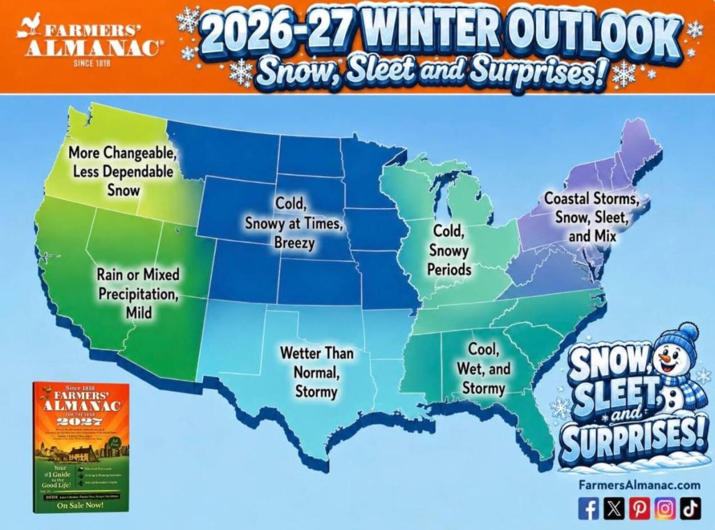
For the upcoming 2026–2027 winter, the Farmers’ Almanac predicts cold and snowy periods for Indiana and the Midwest. The outlook points to a season featuring sudden snow squalls, blustery winds, and frequent temperature swings between freezing and thawing.
Expected Conditions
- Temperatures: Average near normal overall, but interrupted by quick bursts of bitter cold and sudden drops.
- Snowfall: Intermittent snowy periods with potential brief snow squalls, creating fast-changing and unpredictable road conditions.
- General Pattern: Frequent shifts between thawing and freezing rather than a single sustained mild or harsh block.
Long-range winter forecasts for Indiana will continue to be refined through late September as global ocean and jet stream trends stabilize.