

BLOOMINGTON — For the second consecutive year, heavy spring downpours are forcing emergency closures at Lake Monroe.
Monroe Lake officials announced Monday afternoon that the reservoir’s water level has risen to 546.71 feet as of noon on May 18, 2026. This places the lake a staggering 8.71 feet above its normal pool level, triggering immediate closures of recreational facilities ahead of the busy Memorial Day holiday weekend.
The situation could worsen in the coming days. The National Weather Service forecast predicts up to 2.0 inches of additional rainfall through Tuesday night, with another half-inch expected to accumulate on Friday.
While park officials noted the good news that the water has not yet reached the record-shattering heights seen at this time last year, they urged the public to remember the lake’s primary purpose.
“Please remember that we are a flood control reservoir,” Monroe Lake management posted in a public update. “Holding on to excess water to minimize flooding impacts on downstream homes, businesses, and farms is literally why the reservoir was built.”
The rising waters have resulted in a sweeping list of closures and restrictions across the state recreation areas (SRAs):
Beach and Recreation Closures
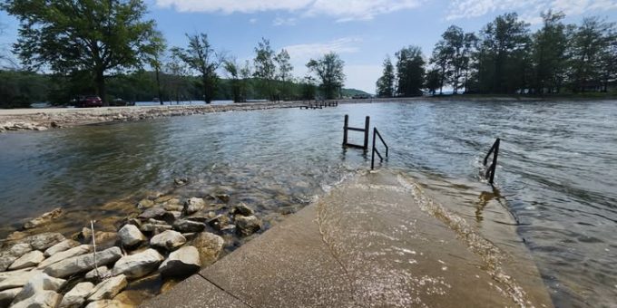
- Swimming Beaches: The swimming beaches at both Paynetown SRA and Fairfax SRA are completely submerged and will NOT open for Memorial Day Weekend. Officials confirmed the beaches will remain closed through at least the end of May, with no current timeline for reopening.
- Fishing Piers: The dedicated fishing piers at Paynetown and Cutright SRA are currently entirely inaccessible due to high water.
- Hiking Trails: Portions of the Tree Trek Trail (Paynetown SRA), as well as the Osprey Trail and Homestead Trail (Fairfax SRA), are underwater. Hikers are warned they will need to backtrack or reroute.
Boat Ramps and Marinas
- Cutright SRA: The main boat ramp is officially closed. However, boaters can still utilize the high-water boat ramp at Cutright, which remains open. All other boat ramps around the lake are currently operating normally.
- Paynetown Marina Access: As of Monday, the peninsula road leading to the Paynetown Marina and the Activity Center (scheduled to open Friday) remains accessible. However, officials warn this could change by the weekend and advise visitors to monitor social media.
- Private Marinas: Privately owned and operated businesses—including Fourwinds Lakeside Inn and Marina, Lake Monroe Boat Rental, Two Herons Marina, and the Lake Monroe Sailing Association—remain OPEN for business.
Road Closures Around the Lake
Local authorities have closed several low-lying roads surrounding the reservoir until water levels recede:
- McGowan Road (including all access to the Stillwater Marsh observation platform).
- Friendship Road (closed from the hunter check station to Gross Road).
- Stipp Road (closed on the east side of Cartop SRA).
Jurisdiction Warning for Campers
Monroe Lake officials clarified that these closures only apply to Indiana State Recreation Areas. Properties managed by the federal government, including the Hardin Ridge Recreation Area, Charles C. Deam Wilderness Area, and the Hoosier National Forest, are operated by the U.S. Forest Service. Visitors holding reservations or planning trips to those federal areas must contact the Hoosier National Forest directly for localized flood updates.
Property managers update reservoir water levels every 15 minutes. Heavy users of the lake can track live automated updates directly via the NOAA National Water Prediction Service gauge at water.noaa.gov/gauges/MONI3.

