

(INDIANAPOLIS) – The Indiana Geographic Information Office is moving forward with a new state-wide orthoimagery project to capture new aerial views of the entire state that will be used to update www.indianamap.org.
The publicly available maps, which will have higher resolution than currently offered, allow for linear and area measurements and are used for a variety of purposes, including by construction companies, utility companies, and for economic development.
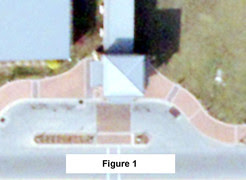
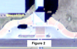
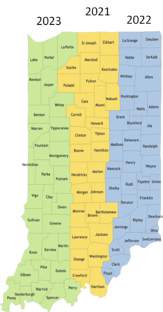
The new orthoimagery is being collected from 2021 through 2023 and is being photographed at 6-inch pixel resolution. (See Figure 1)The higher resolution allows users to identify smaller ground features including such items as manhole covers, fire hydrants, or utility poles. Previously, the state has flown 12-inch imagery. (See Figure 2)
The Sanborn Map Company, Inc. has been awarded the contract to collect the imagery through manned flights that start in March covering the center third of Indiana.
“This statewide program supports a wide range of projects around the state, benefiting economic development, transportation, public health, natural resource management, and public safety,” Indiana Geographic Information Officer Megan Compton said. “I am looking forward to seeing the results of this advanced imagery and its utilization throughout the state.”
Partners in this program include the Indiana Office of Technology (IOT) and Indiana Department of Transportation (INDOT).
There is an opportunity for other Indiana cities, counties and other partners to have more options too, including 3-inch orthophotography and other ancillary products.
“With this imagery, we will have the ability to view current infrastructure and land use, which is vital to understanding opportunities for growth and development,” Indiana Office of Technology Chief Information Officer Tracy Barnes said. “These maps are also leveraged by telecommunication companies as a way to identify places to lay fiber optics for broadband which can benefit our rural communities.”
Founded in 1866, Sanborn Map Company first created highly detailed maps for fire insurance companies to assess their total liability in urbanized areas across the United States. Today, it is a full service, dedicated geospatial solution provider.
The orthoimagery program benefits Indiana by supporting over $1.7 billion in projects related to transportation, economic development, public safety, environmental management and other areas of interest.
Once collected and ready, this high-quality imagery will be available to the public for viewing and download on the Geographic Information Office website

