

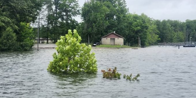
MONROE LAKE — Following a week of heavy rain and severe storms across southern Indiana, officials at Monroe Lake have issued a comprehensive high water update. As of Friday, June 26, 2026, the reservoir sits at 550.26 feet, which is 12.26 feet above its normal pool level.
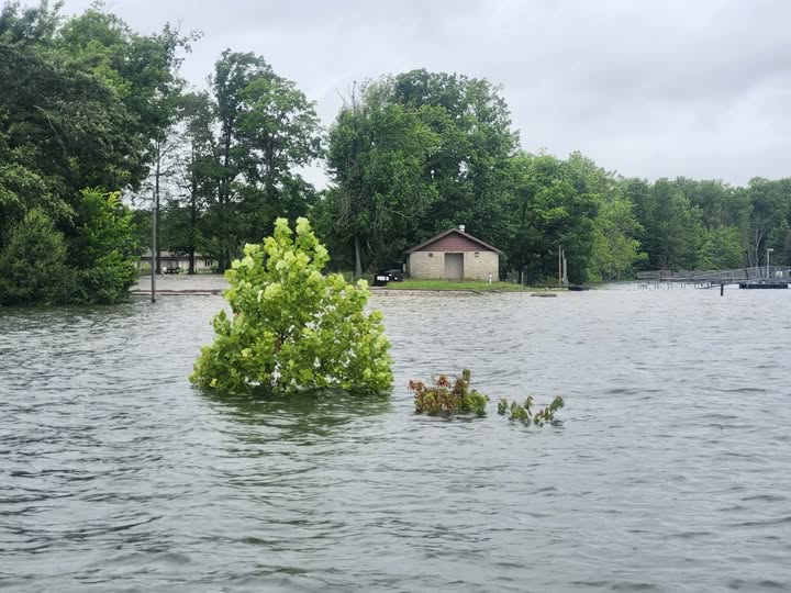
With an additional 36 hours of rainfall projected for the region, water levels are expected to rise even higher by Monday. State park officials emphasize that Monroe Lake is currently fulfilling its vital purpose as a flood control reservoir, holding back excess water to protect downstream homes, farms, and businesses.
While the high water has caused widespread facility closures, officials stress that the lake remains open and safe for boating.
Beach Closures and Boating Safety Guidelines
The most significant impact for summer visitors is the complete closure of the lake’s shoreline recreation areas.
Critical Notice: ALL BEACHES REMAIN CLOSED. Due to the high water levels, officials expect all swimming beaches to remain closed until at least late July.
Despite the beach closures, recreational boating is fully permitted with the following safety guidelines in place:
- Motorized Boating: Operators should exercise extreme caution. High floodwaters routinely sweep heavy debris, logs, and hazards into the main body of the lake.
- Non-Motorized Boating: Kayakers and canoers have a unique opportunity, as the elevated water level has opened up access to hundreds of acres of additional backwater areas.
- Swimming from Boats: Swimming off a boat is permitted. Swimmers are urged to stay close to their watercraft to remain visible to other boat operators and stick strictly to no-wake zones.
- Lifejackets: Boaters and swimmers should ALWAYS wear an appropriate Personal Flotation Device (PFD) while on or in the water.
Real-time water levels are updated every 15 minutes and can be tracked via the National Oceanic and Atmospheric Administration (NOAA) gauge network at water.noaa.gov/gauges/MONI3.
Open Facilities and Marinas
Many core features of Monroe Lake remain fully operational. Visitors can still access the following services:
- Marinas & Rentals: Lake Monroe Boat Rental, Fourwinds Marina, and Paradise Boat Rental are all open. Both Two Herons Marina and Fourwinds Marina have gas available for purchase.
- Camping & Recreation: The campground at Paynetown State Recreation Area (SRA) remains open, with only a few specific sites affected. Naturalist programming is still running, with upcoming schedule details posted on the property’s Facebook Events tab.
- Unaffected Areas: Allens Creek SRA and Crooked Creek SRA are entirely unaffected by the current water levels.
- Courtesy Docks: Docks are available at the Fairfax SRA and Paynetown SRA boat ramps, though they may temporarily have a few inches of water over low spots as levels fluctuate.
Facilities Impacted or Closed by High Water
The high pool level has swallowed up access roads, trails, and lower-lying structures across several State Recreation Areas.
Paynetown SRA
In addition to the beach closure, the Activity Center, Fishing Pier, and the Twin Oaks, Paynetown, and Lakeview Shelters are closed. The southern half of the Tree Trek Trail is underwater.
The Paynetown Marina remains operational, but the main parking area for the docks is completely flooded. A marina shuttle is operating out of the non-electric campground to transport patrons to the buoys and docks. Marine gas sales and the pump dock are currently unavailable.
- Campsite Closures: Non-electric sites P5–P18, P20, P22, P24, P29, P39, P41–P51, and electric sites 171 and 172 are closed.
Fairfax SRA
The swimming beach and the Fairfax Beach Shelter are closed. Hikers will find the lower section of the Osprey Trail and the southern end of the Homestead Loop inaccessible.
Cutright SRA
The main boat ramp is closed, though the designated high-water boat ramp is open. The fishing pier and courtesy dock are unavailable. While the main road to Two Herons Marina is flooded and closed, the marina remains open and is providing alternative access routes to the docks for its customers.
Total Closures: Pinegrove & Cartop SRAs
- Pinegrove SRA is completely CLOSED; the main access road is entirely underwater.
- Cartop SRA is completely CLOSED, as both the eastern and western access roads are submerged.
Moores Creek, Salt Creek, & Wildlife Areas
Courtesy docks at the Moores Creek and Salt Creek boat ramps are unavailable. At the Stillwater-Northfork Waterfowl Resting Area, the observation platform at Stillwater Wetland is completely inaccessible. Additionally, McGowan Road and the southern portion of Friendship Road have been shut down due to high water.
History of the Reservoir
For those stuck inside during the rainy weather, Monroe Lake property naturalists have highlighted a virtual program detailing the history, engineering, and construction of the reservoir as a flood-control mechanism. The educational video can be viewed on the Monroe Lake Facebook Watch Page.

