

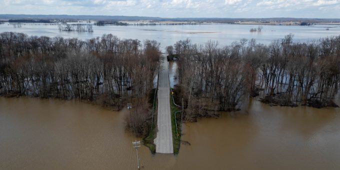
LAWRENCE AND JACKSON CO. — Flood warnings remain in effect for multiple communities along the East Fork White River as high water continues to impact parts of southern Indiana. Officials say the situation could worsen again later this week as another round of heavy rain moves into the region.
In Lawrence County, a Flood Warning remains active for areas near Bedford, Rivervale, and Williams along the East Fork White River. As of the latest observation, the river at Bedford is in moderate flood stage, recently measured at approximately 28.1 feet, significantly above the 20-foot flood stage threshold. Access to the Bedford Boat Club remains blocked by high water, and forecasters say the river is not expected to drop below flood stage until Sunday, March 15.
At this level, flooding typically spreads into low-lying areas near the river and can threaten homes and roads in the floodplain. Forecasts from the National Weather Service indicate that river levels could approach 29 feet, which may cause additional impacts to nearby properties and infrastructure.
Seymour Sees Gradual Improvement — For Now
In Seymour, conditions are slowly improving after the East Fork White River reached a crest of 19.49 feet last week, making it the seventh-highest level recorded there since record-keeping began in 1913.
By early Monday morning, the river had fallen to 16.8 feet, placing it just below the moderate flood stage and within the minor flood category. Current projections show the river continuing to recede, though it is not expected to drop completely below flood stage until Thursday morning.
Despite the temporary improvement, emergency officials warn that the relief may be short-lived.
Another Round of Rain Expected
Meteorologists are monitoring a new weather system expected to bring an additional 1 to 2 inches of rainfall across parts of southern Indiana from Tuesday into Wednesday. The added rain could slow the rate at which rivers fall and may even cause renewed rises in already saturated river basins.
Recent storms have already dropped 3 to 5 inches of rain across portions of central and southern Indiana, producing widespread minor flooding and pockets of moderate flooding along rivers and tributaries throughout the region.
With the ground saturated, even moderate rainfall could quickly run off into creeks and rivers, prolonging the flooding concerns.
Road Closures and Safety Concerns
Authorities in Lawrence and Jackson counties report that several low-lying roads remain closed or impassable due to high water, even as main river levels begin to slowly recede.
Emergency managers continue to emphasize the National Weather Service’s “Turn Around, Don’t Drown” safety campaign.
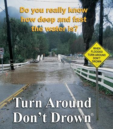
The message aims to prevent one of the most common causes of flood-related deaths: driving into floodwaters.
According to safety officials, just 12 inches of moving water can carry away a small car, 18 to 24 inches can sweep away most vehicles, including SUVs and trucks.
Water covering roads can hide washed-out pavement, debris, or strong currents.
Because it is often impossible to determine the depth or speed of water covering a roadway, drivers are urged to never attempt to cross flooded roads or bypass barricades.
“Turn around, don’t drown” remains the key message for residents as floodwaters persist across the region.
Officials encourage residents living near rivers, creeks, and low-lying areas to continue monitoring forecasts and river levels over the coming days. With more rain possible and waterways already elevated, conditions could change quickly.
Emergency management agencies say they will continue to monitor the situation closely and provide updates if additional warnings or advisories are issued.

