


BEDFORD – The National Weather Service predicts thunderstorms are possible Monday morning, but they will likely taper off by the afternoon and early evening.
Winds will be north to east at five miles per hour, with temperatures around 73 degrees.
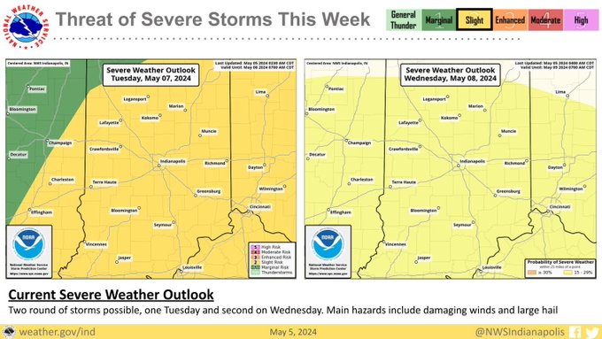
On Tuesday, severe weather is threatened from 6:00 a.m. until 2:00 p.m., with rainfall amounts between a quarter and half an inch possible. Temperatures will be around 79 degrees, and southwest winds will be seven to 13 miles per hour, with gusts up to 20 miles per hour. The showers should taper off by the afternoon to early evening.
On Wednesday, the threat of thunderstorms will continue. There is a slight chance of showers before 11:00 a.m., then a slight chance of showers and thunderstorms between 11:00 a.m. and 2:00 p.m., and then showers likely and possibly a thunderstorm after 2:00 p.m. It is mostly sunny, with a high near 82. The south wind is six to 11 mph. The chance of precipitation is 60%—new rainfall amounts between a tenth and a quarter of an inch, except higher amounts possible in thunderstorms.’
There is a chance of showers and thunderstorms before 8:00 a.m. on Thursday, then a slight chance of showers after 2:00 pm. Mostly sunny, with a high near 77. West wind 14 to 17 mph, with gusts as high as 26 mph. The chance of precipitation is 30%.
There is a slight chance of showers between 8:00 a.m. and 2:00 p.m. on Friday, then showers and thunderstorms after 2:00 p.m. It will be mostly sunny, with a high near 66. The wind will be north-northwest, 11 to 15 mph, with gusts as high as 22 mph. The chance of precipitation is 40%.

