

(LAKE MONROE) – The frequent rain over the past week in Southern Indiana is exacerbating the already high waters at Lake Monroe.
The Army Corps of Engineers says 4 inches of rain fell on Lake Monroe over the past few days. The lake is about 13.5 feet above normal pool. As a result the Corps reduced the amount of water it releases from the dam.
“We can’t open until flood levels downstream drop,” said Park Manager Shannon Phelps.
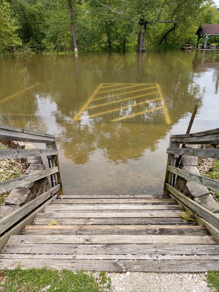
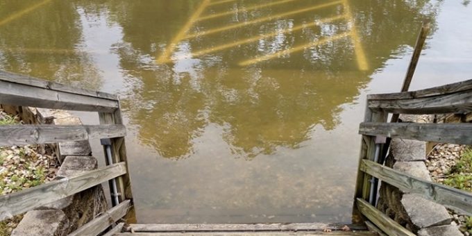
Officials don’t expect water to reach the spillway but it’s something they will continue to monitor. In the meantime, park officials are urging people to use life jackets and extreme caution due to debris and uneven levels in the water.
Some homes on the upper part of the lake are still flooded.
“Toward Brummett’s Creek, Crooked Creek, in those areas. There are a few homes you can’t get to without a canoe,” says Phelps.
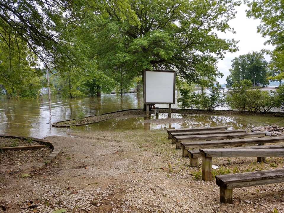
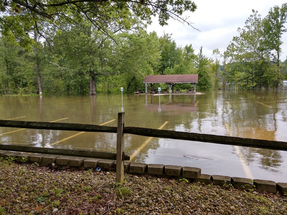
This is forcing some to take alternate routes using kayaks, canoes, and detours to get to their final destination. Water levels are affecting Paynetown Recreation, campgrounds and beaches, causing many to turn around.
The lake’s beaches are closed and boaters are asked to use caution because the water in some areas is much deeper than it has been in the past.
“One of the biggest problems we’re having now with this high-water, it is impacting the campgrounds. There are a number of sites that are closed for the foreseeable future. If you are affected, if you have a reserve site that has been affected, you have been notified,” said Department of Natural Resources Lt. Angela Goldman.
Other information:
Monroe Lake, US Army Corps of Engineers, Louisville District has shut down the discharge from the dam to flood release (200 CFS), due to downstream flooding.
The lake is still OPEN FOR BOATING. Please exercise extra caution due to floating debris and submerged features.
BEACHES: All beaches (Fairfax and Paynetown) are closed.
RAMPS
– Cutright ramps (main and high water) are closed.
– Pine Grove ramp is closed.
– The Fairfax “old” ramp is closed; Fairfax “new ramp” is still open.
– Crooked Creek ramp is closed (but may still be usable for some boats).
– The only courtesy dock that is installed AND accessible is the one at Paynetown.
– All other ramps at the lake are open.
MARINAS / BOAT RENTALS
– Paynetown Marina (run by Monroe Lake): Docks are inaccessible by land. Access to the docks and buoys are by shuttle boat only, which is operating out of the B-loop campground. Fishing dock is inaccessible. Gas sales are suspended.
– Lake Monroe Marina at Cutright SRA (privately-run): Road to marina peninsula at Cutright is under water; marina is inaccessible by land. Please contact the Lake Monroe Marina, Bloomington, 812-837-9394, for updates on boat rentals and access to slips.
– Fourwinds Marina at Fairfax SRA (privately-run): Open and operating. Access to some docks may be under water. Please contact the Fourwinds Lakeside Inn & Marina, 812-824-2628, for updates on boat rentals and access to slips.
– Lake Monroe Boat Rental at Paynetown SRA (privately-run): Open and operating. Lake Monroe Boat Rental, INC, 812-837-9909
PAYNETOWN ACTIVITY CENTER / PROGRAMS: Activity Center is closed. Scheduled programming continues, but has been relocated as needed. Due to high water impacting some facilities, ADDITIONAL activities have been added to the schedule as a service to our guests. See http://bitly.com/monroelakeprograms for a list of programs.
PAYNETOWN CAMPGROUND: Some campsites are closed, with additional sites expected to close over the next few days. The Reservation Center will contact you if you have a reservation for an impacted campsite.
SHELTERS: Lakeview, Twin Oaks, Activity Center, and Paynetown Shelters at Paynetown, and the Beach Shelter at Fairfax are inaccessible.
TRAILS: Flooding is impacting portions of the Big Oak Trail and Evergreen Loop at Fairfax SRA, as well as the Tree Trek Trail at Paynetown SRA. Trails have NOT been inspected for storm damage; hike with caution and please report downed trees and other damage.
CARTOP SRA: Road is under water, no access.
STILLWATER-NORTHFORK: Road is under water, no access.
Please note: We are a STATE government property. Therefore, we do NOT manage Hardin Ridge Recreation Area, the Deam Wilderness, the Pate Hollow Trail, or any other areas of the Hoosier National Forest. Those areas are part of the Federal government and are managed by the U.S. Forest Service – Hoosier National Forest. Please contact their office for info on how flooding is impacting those Federal lands.

