

INDIANA — The National Weather Service (NWS) has issued a Winter Storm Watch for much of Southern Indiana, including Lawrence, Monroe, and Jackson counties, as an expansive winter system prepares to slam the region starting late Friday night.
Winter Storm Watch
- Meaning: Hazardous winter weather is possible, but its timing, location, or exact intensity is uncertain.
- Action: Be prepared and have a plan; conditions could become dangerous.
Winter Storm Warning
- Meaning: A significant winter storm with heavy snow or ice is occurring, imminent, or very likely, posing a threat to life and property.
- Action: Take protective action; travel may become difficult or impossible.
Winter Weather Advisory
Action: Exercise caution, especially when driving; conditions can still be hazardous.
Meaning: Less severe winter weather (like 2-4 inches of snow or freezing drizzle) is expected, causing significant inconvenience but not meeting warning criteria.
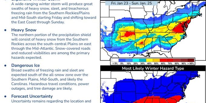
Forecasters are warning of a complex and “impactful” storm that will bring a dangerous mix of heavy snow and freezing rain to the area through Sunday.
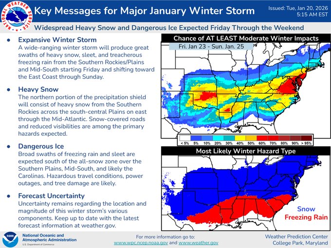
The system, fueled by a clash between a frigid Arctic air mass and moisture from the Gulf of Mexico, is expected to bring heavy snow, sleet, and catastrophic ice from the Southern Plains through the Mid-Atlantic and into the Northeast.
Local Forecast and Timing
Residents should prepare for rapidly deteriorating conditions as the storm moves in from the Southern Plains:
- Friday Evening: A sharp Arctic front will push into Southern Indiana, causing temperatures to plummet into the teens. Light precipitation may begin as early as Friday night.
- Saturday: The brunt of the storm arrives. In areas like Bedford and Bloomington, precipitation is expected to start as a heavy wintry mix.
- Sunday: Precipitation will transition primarily to snow before tapering off by Sunday afternoon or evening.
Snow and Ice Projections
The “cut-off” line for the heaviest snowfall is currently projected to sit directly over the Bedford-Bloomington corridor, making precise totals difficult to pin down.
| Location | Expected Snowfall | Ice/Sleet Potential |
| Bedford / Mitchell | 4 to 7 inches | Significant sleet; up to 0.25″ of ice. |
| Bloomington | 5 to 8 inches | Heavy snow with some sleet mixing in. |
| Seymour / Brownstown | 3 to 6 inches | High risk for freezing rain and significant icing. |
| Paoli / Salem | 2 to 5 inches | Primarily freezing rain/ice threat; up to 0.50″ of ice possible near the Ohio River. |
Travel and Safety Warnings
The National Weather Service in Louisville warns that “dangerous travel and freezing rain” are high-probability threats.
- Flash Freeze: Temperatures are expected to drop 25 to 45 degrees below normal, potentially freezing wet roads instantly on Friday night.
- Power Outages: In areas seeing more than a quarter-inch of ice (particularly south of Hwy 50), the weight on power lines and trees could lead to widespread outages.
- Wind Chill: By Sunday night, wind chills in Lawrence County are forecast to drop between -15°F and -25°F.

