


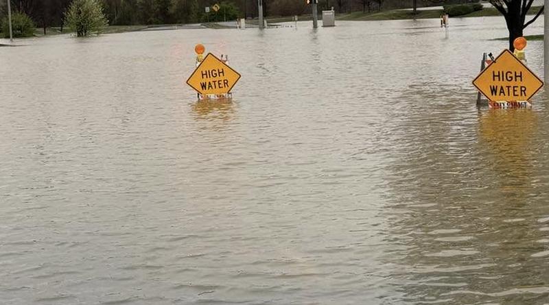
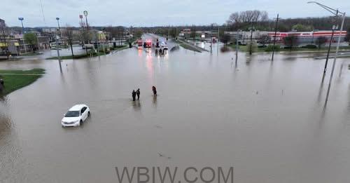
COLUMBUS– Bartholomew County emergency officials advise residents that significant road closures will remain in effect until Monday evening due to widespread flooding. The closures are caused by the swollen East Fork White River and other waterways in the region.
The county has confirmed that State Road 46/Jonathan Moore Pike, a major thoroughfare connecting downtown Columbus to the west side as far as Goeller Boulevard, will remain closed. This closure includes all ramps accessing Interstate 65 at this interchange.
Additionally, State Road 11 from Jonathan Moore Pike south to Walesboro and Southern Crossing are expected to remain closed to traffic.
Bartholomew County Emergency Management has released a list of roads closed due to high water. According to the agency:
Roads Closed:
- Entrance/Exit Ramps I-65 at 68 MM (SR 46)
- SR 46 both directions Goeller to SR 11
- Carr Hill Rd, between Jonathan Moore Pike (SR46) and Morgan Willow
- SR 11 south of the overpass
- Southern Crossing, east of SR11 (Jonesville Rd)
- SR 11, between 650S and 800S
- 800S, east of SR11
- SR11, at 1100S
- Lowell Rd, between 250 W and 325 W
- Georgetown Rd, W of 325 W
- 325 W, between Lowell Rd and Carlos Folger Rd
- 150 E by Southern Crossing
- 250 S, between 400 and 475 W
- 50 N, between 600 W and 675 W
- Newbern Rd, N of the bridge
- Tellman Rd/200 W to Indianapolis Rd
- 200 N between 500 W/325 W
- 10043 N 330 W
- Riverside Dr, beind the Lagoons
- 1200 E between Base Rd and 200 S
- 475 E/100 N
- 330 W, north of 450 N and North of Ohio Ridge Rd
- 300 E/600 S
- Double Y Saddle Club
- SR 58/Spray Rd
- 550 W/Spray Rd
- 900 N, between 300 E and 200 E
- 600 E/850 S
- Water Street
- 100 N/200 W to Indianapolis Rd
- Indianapolis Rd/Arcadia to Indianapolis/Lindsey
- 250 E, between 600 N and Sugar St (Clifford)
- 50 W, between 550 N and 585 N
- 3700 Blk N 250 W
- Tannehill Rd/330 W to Driftwood Bridge
- 340 E, between Azalia and 650 S
- 7590 N 330W- just pass this address
- 15th/Jackson St
- 500 W/Ohio Ridge Rd.
High Water:
- 550 N, between 100 W and 50 W (one lane open)
- 200 S between 400 W and I-65 overpass
- Henry Lakes Blvd to US 31
- Indianapolis/Carl Miske
- Golden Maize Dr
- 800 N/Base Rd
Parks:
- Mill Race South Side
- Noblitt Park
- Clifty Park
- People Trails
- Mccullough Run Park
Sunday afternoon, the East Fork White River in Columbus was recorded at 17.02 feet, exceeding the central flood stage by over a foot and nearing its predicted crest. River gauge predictions indicate that water levels in Columbus are not expected to fall below the moderate flood level until Monday morning.
In addition to the ongoing river flooding in our area, Bartholomew County officials warn of a flash flooding threat at the dam near Youth Camp Road.
Shannan Cooke, the county’s head of Emergency Management, reported that the dam was leaking. A pump is currently working to help lower lake water levels and reduce pressure on the dam.
The Youth Camp is following its emergency plan, which includes notifying residents and calling for a Flash Flood Watch downstream from the dam on Wolf Creek.
The flash flood watch remains in effect until at least Tuesday morning.
Further downstream, the East Fork White River at Seymour was also experiencing major flooding Sunday afternoon, nearing its predicted crest at 19.78 feet. The river is anticipated to recede below moderate flood stage until Tuesday morning.
The Big Blue River at Shelbyville continues to experience significant flooding, having crested earlier today at 19.98 feet, 0.22 feet below the record flood level of 20.2 feet. Water levels are expected to drop below moderate flood stage early Monday morning.
Several other area rivers remain in moderate flood stage:
- Flatrock River at Columbus: At 16.2 feet, 1.2 feet above the moderate flood level of 15 feet. The river is expected to crest this afternoon within the moderate flood stage.
- Flatrock River at Rushville: At 15.01 feet, just above the moderate flood stage. This river has already crested and will return to minor flooding shortly.
- Driftwood River at Edinburgh: At 16.56 feet, 2.5 feet above the moderate flood level. The river is expected to crest momentarily.
- Sugar Creek at Edinburgh: At 16.51 feet, 2.5 feet above the moderate flood level. This river is expected to have already crested in the moderate flood stage.
Good news for some areas: Haw Creek in Hope, Clifford, and Columbus is no longer flooding, and Clifty Creek has also receded below flood stage. The Muscatatuck River at Vernon did not reach minor flood stage.
Due to the ongoing flooding and its impact on transportation, Bartholomew Consolidated Schools and Whitecreek Lutheran School have announced closures for Monday and will implement e-learning days.

