

INDIANA – The National Weather Service has issued a flood watch for Southern Indiana beginning Thursday evening and extending into Saturday afternoon as wet weather heads toward the region.
Thursday temperatures will climb into the middle 60s with on-and-off showers. A cold front will move in through the afternoon, so temperatures will slowly drop into the 50s. Some heavy rain is possible. Heavier rain will move through overnight and into Friday.
Heavy rain and flooding will be the primary threats on Friday, mainly along and south of I-70.
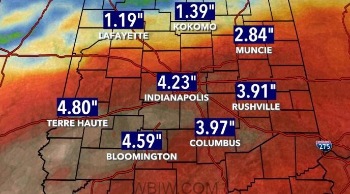
Officials say 2 to 4 inches of rainfall will fall in this system. With already saturated ground, flooding is possible. Localized amounts could be more than 4 inches.
Saturday, temperatures will be in the lower 50s in the morning hours with showers continuing. Temperatures will fall throughout the day and light showers will switch to some flurries mixing in.
Sunday will be mostly cloudy with temperatures in the lower 50s.
As always, never walk, swim, or play in flood waters. Turn around, don’t drown.

