

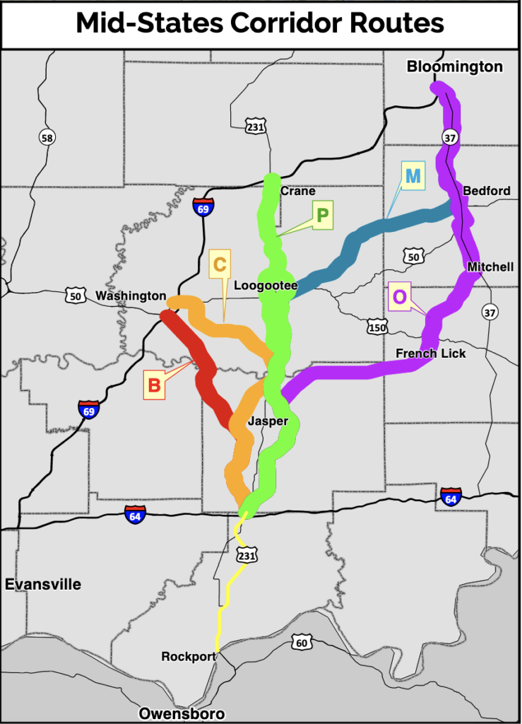
INDIANA – A legal notice in the Evansville Courier & Press on Monday, April 11, shows a selection has been made for the preferred route of the Mid-States Corridor highway improvement project in southwest Indiana. According to the notice, the selection of Route P is being published in the newly completed Indiana Department of Transportation’s (INDOT) Tier 1 Draft Environmental Impact Statement (DEIS) for the project.
“Improvements for Alternative P extend 54 miles from I-64/US 231 to I-69 at the existing US 231 interchange,” the notice states. “It uses existing US 231 between SR 66 and I-64. Construction will begin at the I-64/US 231 interchange continuing east of Huntingburg and Jasper, avoiding developed areas near these cities. From Haysville to the north, Alternative P generally parallels the existing US 231 alignment with a bypass west of Loogootee. This alternative ends at the existing I-69 interchange at US 231. These highway improvements may include a 2-lane or 4-lane facility to be determined during Tier 2.”
While the notice uses the word “construction,” there will be public hearings, meetings, and studies that will need to be complete before construction can begin.
The first public hearing will be held Tuesday, April 26, from 5:30 p.m. until 7:30 p.m. EDT at WestGate Academy in Odon. Doors will open at 5:30 p.m. A second hearing is set for Thursday, April 28, from 5:30 p.m. until 7:30 p.m. EDT at the Jasper Arts Center at Vincennes University Jasper Campus. doors will open at 5:30 p.m. At 6 p.m. a presentation from the project team and a formal public comment session will be held. Spoken comments will be limited to 2 minutes per person. People needing special accommodations to make comments should contact David Goffinet with Lochmueller Group at 812-759-4120 as soon as possible. Team members will also be available to answer questions and hear comments before and after the presentations.
Comments can also be made using comment forms available at the hearings and on the project’s website. The information can then be sent back in via mail or email. In addition, the project’s office at Vincennes University Jasper Campus will be open Mondays, Wednesdays, and Fridays from 8 a.m. until 5 p.m. EDT. The office can be reached at 812-482-3116 or info@midstatescorridor.com. The deadline to submit comments for consideration is May 31.
The Coalition Against the Mid-States Corridor, Indiana Karst Conservancy, Sierra Club Hoosier Chapter, Indiana Forest Alliance, and Hoosier Environmental Council will be holding a meeting on Thursday, April 21, from 6:30 p.m. until 8 p.m. in the gymnasium of Emerson Elementary School in Mitchell. There will be a presentation on the status of the project, its impacts, opposition concerns, and how citizens can participate and voice their opposition and concerns, followed by a Q&A session.
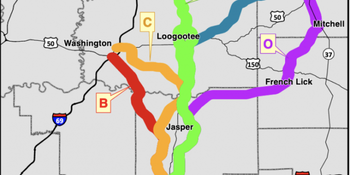
The rejected routes
Reviewing the four rejected routes, beginning at I-64, just north of Dale:
- Route B would have proceeded north, pass to the west of Huntingburg and Jasper, then east of Otwell and Dogwood Lake, to link with I-69 south of Washington.
- Route C would have begun on the same route outlined above until breaking off near State Road 56 and swinging to the north of Jasper. It would have then turned westward, passing through the Alfordsville area and north of Dogwood Lake, to connect with I-69 east of Washington.
- Route M would have followed the same path described above until reaching Loogootee. At that point, the highway would have turned northeast, roughly following State Road 450 through northeast Martin County and western Lawrence County, to meet up with State Road 37 just northwest of Bedford.
- Finally, Route O would have followed the same paths outlined above until passing by Jasper. The road would then have turned east, roughly following U.S. 150/State Road 56 to a point just south of French Lick. It would then have turned north, passing the east side of French Lick and West Baden Springs, before continuing northeast to join S.R. 37 at Mitchell.

