

FLORIDA – Hurricane Ian’s “extremely dangerous” eyewall — just shy of Category 5 strength — is moving onshore in southwestern Florida, with the storm poised to inflict “catastrophic” winds, storm surge, and flooding across a large portion of the state, forecasters say.
Hurricane Ian is barreled toward Florida today, with the center of the storm on track to make landfall on the state’s west coast as soon as the late morning or early afternoon.
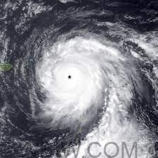
Maximum sustained winds were near 155 mph, with higher gusts, around 8 a.m. ET. That is just 2 mph away from being upgraded to a Category 5.

As of 11 a.m. ET Wednesday, the storm was about 45 miles from Naples, Fla., according to the hurricane center. It had sustained winds of 155 miles an hour.
The National Hurricane Center has warned of “life-threatening storm surge, catastrophic winds, and flooding in the Florida Peninsula,” with millions under evacuation orders.
The latest forecasts show the storm surge could be highest – up to 18 feet- on a 50-mile stretch from Englewood to Bonita Beach. Hurricane Ian was expected to cause tropical storm-force winds extending out 175 miles and as much as two feet of rain.
Tornadoes are also possible across the Florida Keys and the southern and central Florida Peninsula, according to the National Hurricane Center.

It is not yet clear exactly where Ian will make landfall, but Gov. Ron DeSantis said early Wednesday the forecast track showed it hitting Charlotte County as he warned residents it was too late to evacuate the area.

“It’s time to hunker down and prepare for this storm,” Gov. Ron DeSanits said. “This is a powerful storm that should be treated like you would treat” a tornado approaching your home.”
After plowing Wednesday into southwest Florida, Ian’s center is expected to move over central Florida through Thursday morning. Heavy rain also is possible in South Florida, as well as eastern Georgia and coastal South Carolina.
“Widespread, life-threatening catastrophic flash, urban, and river flooding is expected” across central and southern Florida, the hurricane center said. Considerable flooding also is possible elsewhere in Florida, southeastern Georgia, and coastal South Carolina through the weekend, the hurricane center said.
Airports near Tampa Bay, St. Petersburg, and Sarasota closed Tuesday. Schools across the state canceled classes. Walt Disney World said its theme park is closed today and Thursday.
Meanwhile, across Cuba, residents have been left without power after sweeping outages in Ian’s wake.

