

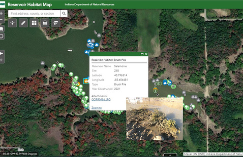
INDIANA – Anglers can find fish habitat structure locations and more on DNR’s new interactive reservoir habitat map.
Habitat structures, such as bundles of Christmas trees, rock piles and wooden platforms, improves aquatic habitat for fish by creating areas for cover, nesting, and more. The structure also attracts bait fish and provides other feeding opportunities.

The new interactive map includes project lakes, structure locations, structure types, and photos of structure types. As DNR completes habitat work in the future, information will be added to the interactive map.
The Reservoir Habitat Enhancement program, which started in 2016, improves and enhances aquatic habitat through the placement of structures, shoreline stabilization, and dredging. Thanks to the help of volunteers and local businesses, DNR has completed projects on multiple reservoirs across Indiana. Projects have ranged in size; one added more than 200 structures, with multiple structure types, to Patoka Lake in 2020. Another smaller project at Bryant Creek Lake in 2019 sank 50 Christmas trees in bundles around the lake.
In some reservoirs, existing aquatic habitat has deteriorated, making the addition of fish habitat structures necessary to improve the fishery. Other reservoirs may have never contained quality habitat. This could be due to water quality, water level fluctuations, land use before reservoir construction, or other issues.
Learn more about the program and access the new interactive map at on.IN.gov/fishhabitat.
Individuals interested in improving fish habitat in their own private ponds or lakes can visit our website for more information: wildlife.IN.gov/fishing/private-pond-and-lake-management.

